2024 GS P1 Solution, PYQs Solution
Q.10. Write a note on seismic zones of India.
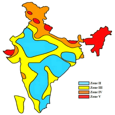
India’s high tectonic activity, primarily due to the collision of the Indian plate with the Eurasian plate, makes a significant portion of its landmass vulnerable to earthquakes. To quantify this hazard, the Bureau of Indian Standards (BIS) has published a seismic zonation map, which classifies the country into four distinct zones (II, III, IV, and V).
This classification is based on scientific data on past earthquakes, tectonic activity, and seismic potential.
- Zone V (Very High Risk Zone): This is the most seismically active region, facing the highest risk of catastrophic earthquakes (Intensity IX and above on the MSK scale). It includes the entire Northeast, parts of J&K, Himachal Pradesh, Uttarakhand, the Rann of Kutch, and the Andaman & Nicobar Islands.
- Zone IV (High Risk Zone): This zone has a high probability of destructive earthquakes (Intensity VIII). It covers the remaining parts of J&K, Himachal, and Uttarakhand, along with Delhi, parts of North Uttar Pradesh, Bihar, and West Bengal.
- Zone III (Moderate Risk Zone): This zone may experience moderate-intensity earthquakes (Intensity VII). It covers a large swathe of peninsular India and parts of Uttar Pradesh, Rajasthan, and Madhya Pradesh.
- Zone II (Low Risk Zone): This zone has the lowest seismic hazard (Intensity VI or less). It comprises the most stable parts of the Indian peninsula, such as large parts of Karnataka, Andhra Pradesh, and Madhya Pradesh.
In conclusion, this zonation is not just a scientific exercise; it is a critical tool for national policy. It forms the basis for disaster management strategies, urban planning, and, most importantly, the mandating of specific structural safety standards and building codes to mitigate risk.